Exhibition
Experience the city of tomorrow today: In our exhibition we show insights into our current projects and other exciting exhibits from the CityLAB partner circle.
The exhibition can be visited free of charge from Wednesday to Friday, 10am to 5pm. We are happy to offer guided tours for groups of more than 5 people on request by email via info@citylab-berlin.org
Current exhibits
| Title | Linkable Texts | Post Content | Featured Image | Link Arrow | Ausgestellt seit |
|---|---|---|---|---|---|
| Treebot | CityLAB Berlin |
Have you talked to a tree today? The Treebot gives Berlin’s urban trees a voice, bringing nature in the city to life. Equipped with a microcomputer, environmental sensors, speakers, and a wireless microphone, this compact device—secured with a handy “trunk pouch”—can be attached to any tree. The sensors capture the tree’s immediate surroundings, and with the help of AI technology, these data are transformed into words. This creates interactive conversations between people and urban nature. The Treebot serves as a playful voice for the tree, sparking thought-provoking reflections on climate protection and the importance of nature in a fun and engaging way. Let’s go! Talk to me. | 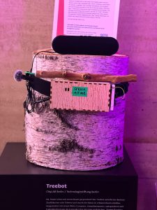 | December 2024 | |
| Berliner Haushaltsdaten | CityLAB Berlin |
How much impact does the Berlin budget have on your daily life? From the expansion of daycare centers and schools to affordable housing, it shapes the social fabric of the city and is therefore of great importance to all Berliners. To increase transparency, the Senate Department for Finance has been providing current and past budget data as machine-readable datasets on the Berlin Data Portal for some time. However, due to their complexity, these data are difficult to understand. To address this, CityLAB Berlin and the Open Data Information Center (ODIS), in collaboration with the Senate Department for Finance, have developed an interactive visualization of the budget data. Users can explore the planned revenues and expenditures of the Berlin administration through an interactive tree diagram. |  | December 2024 | |
| Parla | CityLAB Berlin |
What sustainability goals is the Berlin Senate pursuing to reduce CO₂ emissions? How does the shortage of teachers impact the city, and what initiatives support Berlin’s cultural sector? Schriftliche Anfragen (Written inquiries) are a key tool in our democracy, allowing the public to ask the government or state authorities for specific updates on public measures. Since the administration often lacks a centralized digital knowledge management system, employees in Berlin’s public offices spend significant time gathering and organizing information from various sources as needed. Our prototype Parla uses AI to make information more accessible—both for citizens and for more efficient research within the administration. | 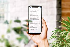 | Dezember 2024 | |
| Anmeldecheck | CityLAB Berlin |
The most common reason for appointment cancellations at Berlin’s citizen offices? It’s not the registration or re-registration of a residence itself, but the forgetting or missing of required documents. The Registration Check helps ensure optimal preparation for your registration or re-registration appointment. By answering a few quick questions about your personal situation, you’ll receive a tailored checklist of all the necessary documents. This prototype, developed in close collaboration with the Ausbildungsbürgeramt Friedrichshain-Kreuzberg, office, is available in seven languages and makes preparing for your visit simple and efficient. | 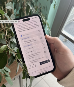 | ||
| Portraitfilm | CityLAB Berlin |
What really happens behind the scenes at CityLAB Berlin? Our documentary takes you on a journey through our work, showing how we’re shaping the city of tomorrow. We actively use Service Design and Prototyping in our daily processes to develop and test solutions for urban challenges. One example is our Kiezlabor, which has been working directly with Berlin’s neighborhoods since 2023 to co-create sustainable ideas. Another highlight is our annual Sommerkonferenz, where urban development, government, and digital innovators come together to share ideas. Let the film begin! | 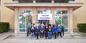 | December 2024 | |
| Kiezcolors | CityLAB Berlin |
How much space do we need for living, moving around, or simply to take a deep breath? A fair distribution of space in cities can make our lives happier and healthier. With Kiezcolors, land use within a 1000-meter radius of any given point is visually represented. By moving the map or searching for a specific address, different locations can easily be explored. The result can be downloaded as a PDF and printed in a handy postcard format. | 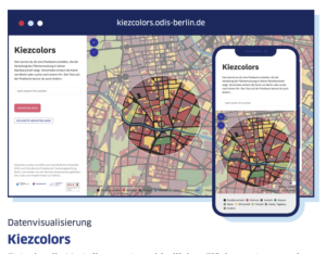 | December 2024 | |
| Chatbot Public Design | CityLAB Berlin |
We have transformed our service design standard work, the Handbuch Öffentliches Gestalten (Public Design handbook), into an AI chatbot that can make the handbook's collective knowledge available in a matter of seconds. This can range from general questions about the handbook, such as "What does the handbook help me with?" or "What are the phases presented in the handbook?" to questions that arise from a specific need, such as "What do I need to consider when preparing a workshop?" or "Which methods are suitable for brainstorming ideas?" | 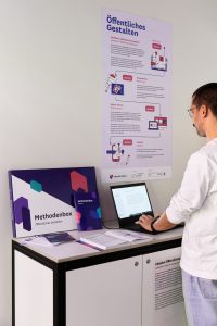 | Oktober 2023 | |
| Kiezbot | CityLAB Berlin |
Beep Boop Beep! The Kiezbot is here! We let a voice AI slip into three different roles, taking interaction with artificial intelligence to the next level. Are you interested in topics such as sustainability and climate change? Then Kiki, the friendly bee, is the right conversation partner for you! Our robot Iris simply knows everything remotely to do with technology, but watch out, she's a bit arrogant. Ernst, the currywurst, is the biggest Berlin expert around. Sometimes a bit gruff, but you're sure to take him to your heart very quickly. Have fun trying him out! | 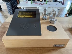 | October 2023 | |
| Hilf-Mir.Berlin | CityLAB Berlin Senate Department for Science, Health and Care (SenWGP) |
People who are looking for help in personal crisis situations often have to click through numerous websites to find the right offer for them. This takes time and patience - both of which very few people can provide. Our platform Hilf-Mir.Berlin brings together the services of over 230 counselling centres in Berlin in one overview for the first time. To make it as easy as possible for those affected, we have placed great emphasis on a simple but comprehensive search function. With just a few clicks and filter options, people can quickly find help that suits their individual needs. In the next step, all counselling services are displayed on a map and clearly arranged in a list. A quick help page with emergency numbers and frequently asked questions rounds off the information service, which was developed with the expert support of the Senate Department for Science, Health and Care. | 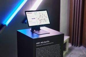 | October 2023 | |
| Visual Utopias | Jan Kamensky |
In the spring of 2020, Hamburg-based artist Jan Kamensky launched his project featuring utopian animations. The deserted streets at the beginning of the pandemic inspired him to create videos in which car-filled streets are playfully transformed into inviting, people-friendly spaces. The video shows the transformation of Skalitzer Straße and Karl-Marx-Allee in Berlin. There is a clear intent behind this approach: once viewers have glimpsed the utopian vision, their perspective on reality becomes more critical. As such, the project is an invitation to us all to reflect on how we want to live in urban contexts.. Jan Kamensky is more interested in raising awareness than in whether or not his visualizations are feasible – but he’d still be thrilled to see his ideas put into practice! | 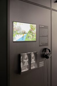 | 2023 February | |
| Baumblick App | Quantified Trees (Qtrees) |
How can artificial intelligence (AI) help with the efficient watering of trees? Our Quantified Trees (QTrees) research project focuses on quantifying the current condition of Berlin's urban trees, which are increasingly suffering from the effects of climate change. The app “Baumblick” shows whether an individual tree is being adequately supplied with water. Sensors are used to measure the so-called soil moisture tension to determine how dry or wet the soil is. Using an AI model to analyze this data, we then attempt to identify patterns and predict the current and future water supply for all city trees up to 14 days in advance. The app also raises awareness for the topic of urban tree care and watering trees and invites people to get involved, thereby helping to improve the AI model. | 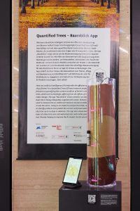 | 2023 February | |
| Gemeinsam Digital: Berlin | Team Gemeinsam Digital: Berlin |
Berlin has a new smart city and digital strategy: Gemeinsam Digital: Berlin. The strategy creates an important basis for combining the topics of smart city, digital strategy, and administrative digitization, including digital citizen services. Overseen by the Chief Digital Officer, these previously diffuse subject areas are being consolidated and reimagined through a more future-oriented lens. The strategy was developed in a participatory process coordinated by CityLAB that lasted almost two years and involved more than 2,000 citizens from across Berlin. The strategy includes a compass of values and defines various fields of action, as well as initial measures and an implementation concept for the digitization of Berlin. Smart City Berlin stakeholders will continue to be involved in the implementation of the strategy. | 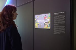 | 2023 February | |
| Stadtpuls | CityLAB Berlin Technologiestiftung Berlin |
Stadtpuls is an open data platform for Internet of Things projects in Berlin that supports the collection and visualization of sensor data and makes it available for further data analysis. This data helps to dive deeper into the world of urban sensor technology and to better understand one's own city, thereby answering questions such as: “How loud is it in my street? What is the CO2 level in my classroom? What is the particulate matter level outside my front door?”. Stadtpuls offers the sensor data freely and brings together Makers such as municipal companies, school projects, researchers, hobbyists and users such as data scientists, data journalists, scientists. | 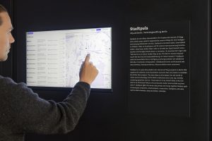 | 2022 June | |
| A Machine View of Berlin | Certain Measures |
How can artificial intelligence help us better analyze and plan our cities? Thanks to AI-supported technologies, it’s easier than ever to analyze massive amounts of data in a short timeframe, allowing us to generate valuable insights that might otherwise have been undetectable by human eyes. In the Project "A Machine View of Berlin", you can observe an AI-powered tool working in real-time as it analyzes and then sorts hundreds of thousands of Berlin buildings based on their shapes. This data basis can be used to generate new kinds of maps that highlight the unique architectural language of a city, for example. This project is part of the "FormMaps" series from Certain Measures, a Berlin design studio. |  | 2021 September | |
| Digital Vereint | CityLAB Berlin |
The Corona pandemic posed major challenges for more than just our places of work: Berlin’s many civil society organizations and initiatives also had to shift their work to the digital sphere on an ad hoc basis. This transition was anything but smooth for many such groups, given that digital expertise and relevant resources are in short supply in many areas of volunteer engagement. The platform Digital Vereint, developed by CityLAB, offers Berlin civil society organizations, volunteer initiatives and non-profit organizations support in the use of digital technology to advance their work. The platform provides free open source software for digital collaboration, as well as networking opportunities, workshops and information on digital topics. | 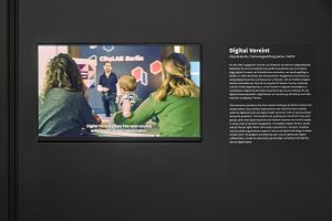 | 2021 September | |
| Berlin Refreshment Map |
Berlin summers are marked by long days with extended sun exposure, with the morning and mid-day especially having a lot of direct sunlight. Our “Berlin Refreshment Map” project helps Berliners find shaded areas at different times of the day and suggests cool outdoor places where you can get a respite from the sun. The map uses data on the height of buildings and objects in the city to simulate the amount of sunlight and shadows found at different locations at different times of day. Users can enter a specific location in the search bar to locate the estimated sun exposure of that location and to find nearby locations ideal for a break from the sun and heat. | 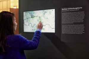 | 2021 September | ||
| Gieß den Kiez | CityLAB Berlin Technologiestiftung Berlin | Gieß den Kiez - “Water your neighbourhood” - is a platform for coordinating the watering of Berlin’s trees. The map shows almost all street and park trees with specific information for each tree, such as its estimated water demand, age and species. It further invites all citizens to parti- cipate in watering our struggling tree population. Citizens can inform themselves about the water demand of trees in their neighbourhood, mark when and how much they have watered and “subscribe” to trees that they regularly take care of. The calculation of the water needs of an individual tree also includes up-to-date precipitation data. Currently, the map depicts about 625,000 trees. | 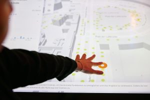 | 2020 August | |
| Shared Mobility Flows | When and where are most rental bikes ridden? Via the programming interfaces of various rental bike providers, data is collected and the routes travelled are visualised. Individual days can be selected and the rides are displayed over the course of the day. Mobility providers such as car sharing, rental bikes or e-scooters create new data sources on the mobility behaviour of a city. In the future, these data could represent an important resource for urban planning with regard to mobility issues. | 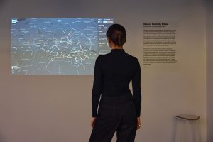 | 2019 June | ||
| Open Data Cam | HTW | For the research project „Open Traffic Count“, we used an AI camera capable of recording traffic flows in real time and differentiating between different types of vehicles and road users (i.e., cars, trucks, buses, bicycles, and pedestrians). No video images are stored during the real-time evaluation, which makes intelligent traffic analysis and counting possible even under strict data protection guidelines. The collected data could be made available to the general public as open data. | 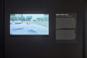 | 2020 February |
Past exhibits
| Title | Excerpt | Post Content | Featured Image | Link Arrow | Ausgestellt von |
|---|---|---|---|---|---|
| Summer School – Radbahnflow | Exhibition Experience the city of tomorrow today: In our exhibition we show |
In our annual Summer School, students investigate the prerequisites for the usage of new technologies as well as the effects of these technologies on different aspects of the habitat "city". In 2022, our student researchers were called upon to further develop a “green wave assistant”, the Radbahnflow. The so-called Green Wave is designed to help cyclists reach their destination more smoothly and safely. Using approaches like physical computing and machine learning on microcontrollers and accompanied by workshops and impulse lectures, the students created a prototype based on the open source model "Leezenflow" from Münster, which has already been successfully implemented. The Radbahnflow can connect to the Internet, display traffic light phases, and use its sensors to hear and see things that would otherwise remain hidden. The Radbahnflow is a friend to all road users! | 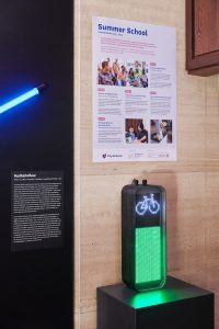 | 2023 February | |
| Carbon Cycle City | Exhibition Experience the city of tomorrow today: In our exhibition we show |
Neonature is a creative partnership between illustrator Johannes Fuchs and biodesigner Kassandra Huynh. Together they create speculative design and proactive art for a "neonatural" planet where humans and nature live together in balance. "Carbon Cycle City" is a vision for the near future of a carbon-neutral city that transforms toxic carbon emissions into valuable resources. It aims to tell a new story, of a Berlin where carbon is sequestered, recycled, (re)stored and transformed into life-friendly forms. Through 360° illustration with accompanying audio narratives of visionary and emerging technological initiatives, it aims to show how every member of our society can benefit and contribute to transforming Berlin into a carbon neutral city. | 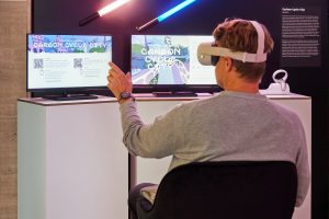 | 2023 February | |
| Berlin Sidewalk Widths | Exhibition Experience the city of tomorrow today: In our exhibition we show |
As part of the pandemic-driven social distancing guidelines, people have been advised to keep at least 1.5 meters distance from each other. That can sometimes be difficult, especially where pedestrian walkways are narrow. ODIS has developed a map application that shows how Berlin’s neighborhoods differ from each other in terms of sidewalk infrastructure and which streets may make it difficult to maintain a minimum distance of 1.5 meters from others. This visualization of sidewalk widths is based on data on sidewalk locations from a 2014 street survey dataset published by the Berlin Senate Department for the En- vironment, Transport and Climate. |  | 2021 September | |
| ZLB Bürgerterminal | Technologiestiftung Zentral- und Landesbibliothek Berlin Verbund der Öffentlichen Bibliotheken | Many citizens find interacting with digital technology difficult or even impossible for a variety of reasons. As a result of these struggles, these citizens are unable to access various online services, including digital public services provided by the local government. | 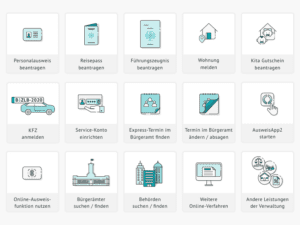 | 2020 Oktober bis 2021 März | |
| DustVR | Michael Saup immersive.earth |
Today, cities across the world are fight- ing against the proliferation and concentration of particulate matter – aka air pollution – within their boundaries. These particles are too small to be seen with the human eye, and while electronic sensors can give us precise measurements to tell us just how much pollution there is in our air, these remain ab- stract concepts – it’s difficult for the average citi- zen to understand just how dirty (or clean) our air is based on a number. In his project DUST, the artist Michael Saup uses virtual reality technology to render the normally invisible realm of urban air pollution (as well as its effect on people) both visible and accessible. Saup presents the city of Berlin with 3D “pixel clouds” that are constantly changing based on real-time measurements from a fleet of citizen-built sensors that feed their data into the open data network luftdaten.info. | 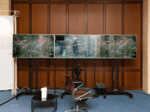 | 2019 June - 2021 March | |
| Platform for Urban Exchange | StadtManufaktur | It is vital for groups involved in an urban planning process to have access to all relevant information. The pilot project “Platform for Urban Exchange” was therefore developed as a communication and planning platform for the creation of urban planning scenarios. A screen and a physical model above help to present the publicly accessible planning materials. The platform, once deployed in workshops with experts and civic representatives, can help simulating planning scenarios, as presented here using the example of the area of Berlin Neu-Hohenschönhausen. Possible effects on the environment and their correlations are shown immediately, making decisions easier and more inclusive. The StadtManufaktur and the "Chair for Urban Resilience and Digitalization" at the TU Berlin cooperated in developing this prototype. |  | 2020 November | |
| Berlin in Minecraft | Technologiestiftung Berlin con terra | Minecraft is a popular computer game that allows players to construct imaginative worlds built solely out of individual blocks. The Minecraft world you see here is based on the 3D city model of Berlin (which is made available as open data); in it, multiple players at once can set to work designing a brand-new Berlin according to their own personal visions. This project presents one way to make a complex topic like urban planning accessible – and enjoyable! – for youths. Minecraft is a popular computer game that allows players to explore and construct elaborate worlds built solely out of individual, cube-shaped blocks. The gameplay is largely uncomplicated, meaning that the only limit to what you can create is often only your patience for putting all of the necessary blocks together to realize your vision. Leveraging the game’s popularity among young people, the Technologiestiftung Berlin together with con terra GmbH and the social initiative Joblinge developed a Minecraft version of Berlin’s city center. This Minecraft map, based on a 3D model of the city that had already been made available as open data, was then used by a group of at-risk youth to explore the topic of city planning in a creative, interactive way. What are the needs of citizens living in Berlin, and how can and should the city be designed to meet those needs? Starting with questions like these, the group of teenagers went around Berlin interviewing citizens, city planners, and architects. Using the information gathered in these conversations, the teens then used the Minecraft map to build an alternative vision of Berlin’s Alexanderplatz, featuring elements like more trees, more water features and more spaces for relaxation. You can explore the Minecraft map of Berlin – and maybe even do a bit of re-designing yourself – using the monitors and controllers in the CityLAB exhibition. | 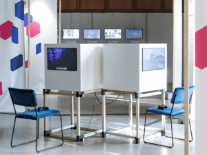 | 2019 June - 2021 March | |
| Government Chatbot | ITDZ Berlin | This „Virtual Citizen Services Assistant“ is the result of a research cooperation between the ITDZ Berlin (IT Service Center Berlin) and the DAI Laboratory at the TU Berlin. The chatbot uses data from the Berlin Government Service Portal and is available 24/7 to answer queries about government services, such as questions about fees, required documents or opening hours of government offices. The chatbot is able to do all of this in nine different languages. It’s currently in beta and is being actively developed. When is my local Bürgeramt open? What documents do I need to bring to apply for a driver’s license? How much does it cost to get a new ID issued? Finding answers to these questions amidst the jungle of Berlin’s bureaucracy is not always easy. But Bobbi the ChatBot is here to help! Bobbi is a “Virtual Citizen Services Assistant” and is the result of a research cooperation between the ITDZ Berlin (IT Service Center Berlin) and the DAI Laboratory at the Technical University Berlin. The chatbot uses data from the Berlin Government Service Portal and is available 24/7 to answer questions about government services. The chatbot is also able to give responses in nine different languages – a critical feature in a city as diverse as Berlin – thanks to a machine learning-enabled translation service. When interacting with Bobbi, it’s important to remember that he only has knowledge about government services – you can’t use him to ask about the weather in Berlin, or to find the nearest bank ATM, for example. This chatbot is currently in beta, so it’s a work in progress that will be continually improved. | 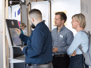 | 2019 June - 2021 March | |
| Visions of an Algorithmic City | Technologiestiftung Berlin | How might an artificial intelligence imagine the city of the future? This “pen plotter”, developed here in the CityLAB, uses a learning algorithm to sketch a new city plan every day. The algorithm is fed a basis of data consisting of the layouts of various existing cities. The AI then uses various techniques to interpret, reconfigure and process the data. The source code for the plotter is open source and is free to be changed, adapted and developed further. | 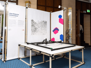 | 2019 June - 2021 March | |
| Berlin's Circular Ecosystem | Circular Berlin | This living document made by Circular Berlin maps Berlin-based organizations and projects working in the circular economy field in order to help make this vibrant community more visible. The map has been put together via an open, collaborative process that included workshops and publicly editable databases and is regularly updated. | 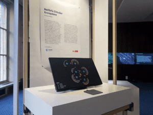 | 2019 November - 2021 March | |
| Tactics for a Sustainable Future | MOTIF Institute | During Science Week Berlin the MOTIF Institute together with CityLAB Berlin organized a participative event to develop ideas & tactics for a sustainable future. More than 100 participants worked on challenges in a t otal of six diff erent areas: E-Mobility, Forest Decline, City Administration, Energy, Affordable Housing and Artificial Intelligence. The tactics presented in the exhibition are intended to invite all visitorsto an active discourse. | 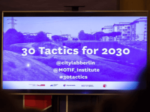 | 2019 December - 2021 March | |
| Transformation der Verwaltung | HTW | With the support of CityLAB Berlin and numerous cooperation partners, including the Pankow District Office and the Senate Department for Integration, Labor and Social Affairs, students at HTW Berlin (Berlin University of Applied Sciences for Engineering and Economics) spent a semester researching why only 10% of eligible applicants in Berlin (and 30% of eligible applicants in Germany) actually access the services made available to them via the the education and participation package (BuT). Project participants analyzed the application process from the perspective of the citizens, conducted interviews, tested out different types of information sources, and in the end they identified some exciting findings. Based on these findings, the students then developed ideas on how the services provided under the BuT program can reach more eligible people. A temporary exhibition hosted by the CityLAB presented interactive approaches for how to remove stigmatization associated with using BuT services, increase access to said services, and rethink how language is used in the context of the program overall. The exhibition also provided insights into what a cooperation between the city administration and a design school (in this case, HTW) could look like. The exhibition launch in September 2020 also laid the groundwork for a later interactive workshop with city employees responsible for the BuT program to explore how to improve the program in a user-centred way. |  | 2020 October - 2020 October | |
| Accessibility in the digital city | FabLab Prototypes Collective | For those with disabilities, the digitalization of cities can sometimes lead to new challenges. But, if thoughtfully implemented, digitalization can also help break down existing barriers. In a series of co-creation workshops, Berlin’s FabLab has been working with people with disabilities to create prototypes that aim to improve everyday life for such individuals. Wherever possible, these prototypes emphasize the use of affordable materials and open source technologies. Smart cities and digital cities are supposed to be for the benefit of all citizens, yet all too rarely do we hear about how we can use technology – especially open source technology – to improve the lives of people with disabilities. Berlin’s FabLab is doing their part to create a more inclusive conversation around smart cities and digitalization through the development of open-source prototypes specifically targeted toward individuals with disabilities. Within the “Made for My Wheelchair” project, the FabLab has helped develop both “Open Lights” and “Open Trailer”. With Open Lights, individuals can create their own customizable lighting system for wheelchairs so that wheelchair users can be more easily seen at night. With Open Trailer, individuals can create a trailer for transporting goods (like boxes or crates) that can be attached to the back of a wheelchair. In both cases, the instructions for designing the systems are available online for free, and the required materials can be ordered online and, in some cases, produced with 3D printers. The other prototype on display in the lab is the “Vorleser” (or, “reader”), which was developed as part of the “Open Health HACKademy”. This DIY-device can read printed texts out loud for individuals with limited vision, and it is much cheaper to produce than other similarly-functioning devices. | 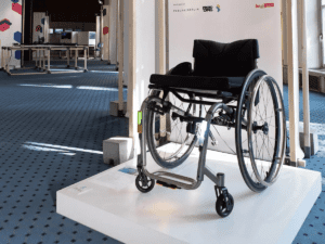 | 2019 June - 2020 December | |
| Berlin Underground | SenUVK Berlin | The Senate Department for the Environment, Transport and Climate Protection is presenting Berlin’s geological model as an interactive, 3D application. The large touch screen visualises the movement and melting of glaciers during the ice age, processes that shaped Berlin’s terrain as we know it today. This display offers information on the various subterranean layers upon which the city of Berlin sits, including layers that date back to the quaternary and tertiary periods. In addition, visitors can undertake their own virtual drilling projects and explore how the city’s subterranean layers vary across different locations. What’s under your feet right this moment? Sure, there’s the fabulously retro CityLAB carpet, and probably a fair amount of concrete under that. But if you look further – 10, 100, 1000 meters below the ground – what would you find then? This interactive table from the Senate Department for the Environment, Transport and Climate Protection offers users a chance to explore layers of various rock types that make up the Earth’s crust underneath Berlin, with the variety of layers representing the tens of thousands of years of geological history. You can rotate the map to get a better perspective of how these layers vary across the city, or you can select a location on the map (say, Platz der Luftbrücke) and virtually bore into the ground to get an image of what kinds of rock layers exist right under your feet. | 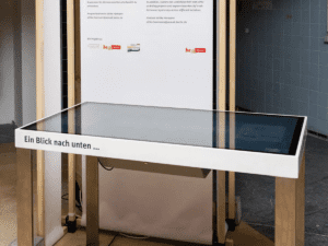 | 2019 June - 2019 September | |
| A network for senior citizens | Place/making GESOBAU Netzwerk Märkisches Viertel | In Berlin’s Märkisches Viertel, an information and interaction network has been providing senior citizens with information on local social infrastructure since 2017. This network was developed collaboratively within seniors living with the district and provides current information on events, senior-oriented offerings other relevant information. It also has a specific focus on increasing media skills among senior citizens via the educational course “CyberSeniors”. Using their mobile infopoint, coordinators of the online network travel around the district and demonstrate the its capabilities to local seniors. These in-person appearances are accompanied by printouts of current offerings from the site, allowing seniors unfamiliar with the site to get a first-impression of what it has to offer without having to first log on to a computer. | 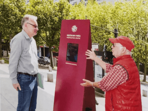 | 2019 June - 2019 September | |
| The politics of data | Tactical Technology Collective | "Smart cities are data-driven cities. But who owns urban data and who can decide what becomes public and what remains hidden? Where does the protection of privacy become more important than efficiency or convenience? At a time when people almost permanently leave behind data traces, these questions are highly political. Tactical Tech is a Berlin-based non-profit organization that works at the interface of technology, human rights and civil liberties. The collective offers training, publishes studies and develops cultural interventions on the socio-political debate on cyber security, privacy and data ethics. |  | 2019 June- -2019 September | |
| WindNODE Live! | Windnode SINTEG | Where does sustainable electricity come from in the middle of a wind-free night? Intelligent energy management plays a critical role in the creation of a climate-neutral city. Given that the availa- bility of wind and solar energy is constantly fluc- tuating based on environmental factors, we need new, flexible solutions that ensure the availability of energy can be matched to demand at any given point. Through the project WindNODE, researchers are testing out new technologies and services as part of a digitally-informed transition toward more renewable energy usage. The WindNODE “diora- ma table” offers an interactive overview of how this project is developing solutions for a stable and se- cure energy system of the future. | 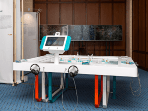 | 2019 June - 2019 September | |
| NERA E-Motorcycle | BigRep GmbH |
NERA is the first functional 3D-printed electric motorcycle – made in Berlin! Only the motor and the electronic components were manufactured in a conventional way and then implemented in the printed materials. The additive manufacturing method of a 3D printer enables time and cost-ef- ficient production. Even though the NERA proto- type itself is the only one of its kind, the technol- ogy developed for it has crossed the boundaries of mechanical engineering and set a new bench- mark for innovative design. | 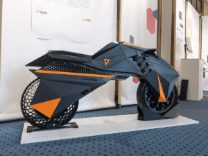 | 2019 October - 2020 January |